What Surveying Equipment Do Surveyors Use? (Complete Guide for Beginners)
What Is Surveying Equipment?
Surveying equipment refers to the tools and instruments used to measure distances, angles, elevations, and positions on the surface. These tools are essential in industries such as construction, civil engineering, land development, and infrastructure planning.
Modern surveying relies on a combination of advanced digital instruments and traditional tools to ensure high accuracy and efficiency in data collection.
Essential Surveying Equipment List
Surveyors typically use a combination of instruments depending on the project type. Below are the most essential tools used in modern surveying.
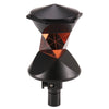
1. Total Station
A total station is one of the most important instruments in surveying. It combines an electronic theodolite with a distance meter to measure angles and distances simultaneously.
Key functions:
Measure horizontal and vertical angles
Calculate distances with high precision
Record and store data digitally
Common use cases:
Construction layout
Topographic surveys
Infrastructure projects
2. GPS / RTK GNSS Receiver
RTK (Real-Time Kinematic) GPS systems provide highly accurate positioning data in real time.
Why it’s important:
Centimeter-level accuracy
Faster data collection
Ideal for large-scale land surveys
Used for:
Land mapping
Road construction
Agricultural surveying
3. Surveying Tripod
A surveying tripod provides a stable base for mounting instruments such as total stations, GPS receivers, and levels.
Why it matters:
Ensures measurement stability
Reduces vibration errors
Improves overall accuracy
Common types:
Aluminum tripod (lightweight & affordable)
Fiberglass tripod (more stable & durable)
Choosing a high-quality tripod is critical, as even small instability can lead to inaccurate measurements.
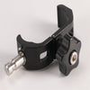
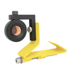
4. Prism (Reflector)
A prism is used together with a total station to reflect the signal back to the instrument for precise distance measurement.
Types of prisms:
360° prism
Mini prism
Monitoring prism
Function:
Enhances measurement accuracy
Enables long-distance measurement

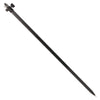
5. GPS Pole / Prism Pole
GPS poles and prism poles are used to hold GNSS receivers or prisms at a fixed height.
Key benefits:
Ensures consistent measurement height
Improves field efficiency
Easy to transport and adjust

6. Laser Level / Auto Level
These tools are used to determine height differences and ensure level surfaces.
Laser Level:
Projects a visible laser line
Ideal for indoor and construction work
Auto Level:
Optical instrument
Common in traditional leveling tasks
7. Measuring Tools (Tape, Staff, Accessories)
Basic tools still play an important role in surveying.
Examples:
Measuring tape
Leveling staff
Reflective targets
Field accessories
How These Surveying Tools Work Together?
Surveying equipment is rarely used alone. Instead, surveyors combine multiple tools to achieve accurate results.
Example setups:
Total Station + Prism + Tripod
→ Used for precise angle and distance measurements
RTK GPS + GPS Pole
→ Used for fast and accurate positioning
Auto Level + Staff + Tripod
→ Used for elevation measurement
Understanding how these tools work together is key to improving efficiency and accuracy in the field.
What Surveying Equipment Do Beginners Need?
If you're new to surveying, you don’t need every tool at once. A basic setup is enough to get started.
Recommended beginner equipment:
Surveying tripod
Prism + prism pole
Basic level (auto level or laser level)
As your projects grow, you can upgrade to more advanced equipment like total stations and RTK systems.
How to Choose the Right Surveying Equipment?
Choosing the right equipment depends on several factors:
1. Accuracy Requirements
High-precision projects require advanced tools like RTK GPS or total stations.
2. Project Type
Construction → total station + tripod
Land surveying → RTK GPS
Indoor work → laser level
3. Material & Durability
Aluminum → lightweight and cost-effective
Fiberglass → more stable and weather-resistant
4. Budget
Balance between cost and performance. Investing in reliable equipment can save money in the long run.
Common Mistakes When Choosing Survey Equipment
Avoid these common mistakes when selecting your tools:
Choosing equipment based only on price
Ignoring stability (especially tripods)
Using the wrong tool for the job
Overlooking compatibility between devices
Making the right choice from the beginning can significantly improve your work efficiency and accuracy.

Conclusion
Surveyors rely on a wide range of equipment to complete their work accurately and efficiently. From total stations and RTK GPS systems to tripods and prisms, each tool plays a critical role in the surveying process.
For beginners, starting with the essential tools and gradually upgrading is the best approach. Choosing the right equipment not only improves accuracy but also enhances productivity in the field.
)